

The United Nations General Assembly has overwhelmingly backed an African-led campaign to promote world maps that more accurately reflect the true size of continents, particularly Africa.
The “Correct the Map” resolution, led by Togo and supported by African Union (AU) member states, was adopted on Friday by 164 votes to one, with six countries abstaining. The United States was the only country to vote against the resolution.
The resolution seeks to encourage governments, schools, international organisations and other institutions to use map projections that provide a more accurate representation of the relative size of land masses.
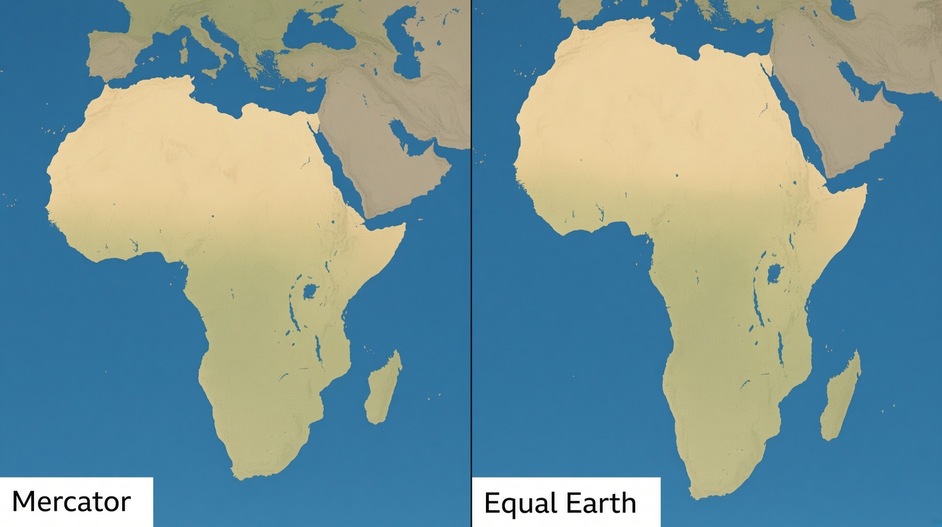
However, the vote does not impose an immediate worldwide replacement of the Mercator projection. Instead, it promotes the use of equal-area projections, including the Equal Earth map, where accurately representing the size of regions is important.
Why Africa appears smaller
The campaign centres on the Mercator projection, created by Flemish cartographer Gerardus Mercator in 1569.
The projection was designed primarily for navigation and has remained one of the world’s most recognisable map formats. However, because it represents the curved surface of the Earth on a flat map, it significantly distorts the size of land masses.
Countries and regions closer to the poles appear much larger than they actually are, while areas around the equator are shown as comparatively smaller.
One of the most striking examples is Greenland, which can appear similar in size to Africa on a Mercator map. In reality, Africa covers about 30.4 million square kilometres, making it roughly 14 times larger than Greenland.
Supporters of the “Correct the Map” campaign argue that the distortion is more than a technical issue because maps can influence how people understand the geographical, economic and political importance of different regions.
Togo’s Foreign Minister Robert Dussey has been a leading voice behind the campaign.
“A fair world begins with a fair map,” Dussey said ahead of the UN vote, according to Reuters.
The campaign is supported by African advocacy organisations Africa No Filter and Speak Up Africa, which have argued that Africa’s distorted representation contributes to outdated perceptions of the continent.
Equal Earth projection promoted
An alternative is the Equal Earth projection, developed in 2018 by cartographers seeking to preserve the relative area of continents more accurately.
The African Union backed the campaign earlier this year, supporting efforts to promote more accurate representations of Africa in global maps, educational systems, media and geospatial platforms.
The Equal Earth projection does not attempt to preserve every characteristic of the Mercator map. Instead, its key strength is that the relative areas of land masses are represented more accurately.
The UN resolution could therefore encourage institutions and technology companies to reconsider the projections they use when the relative size of continents is important.
Debate over the politics of maps
Supporters of the resolution say maps are not simply neutral tools for navigation. They argue that the way continents and countries are depicted can influence perceptions of their importance and place in the world.
“A map is never neutral. It shapes perceptions, influences how the place of peoples and continents in the world is understood,” Dussey said at a UN briefing.
The campaign has consequently become part of a broader debate about how Africa is represented globally and the lasting influence of colonial-era perspectives.
Critics, however, have questioned whether the UN General Assembly should focus on cartographic representation while major international challenges remain unresolved.
Despite the controversy, Friday’s vote represents a significant diplomatic victory for the African-led campaign.
The practical impact of the resolution will depend on whether governments, educational institutions, publishers, international organisations and digital mapping companies voluntarily adopt alternative projections.
For supporters of “Correct the Map”, the issue is ultimately about ensuring that the world’s visual representation reflects geographical reality more accurately — particularly when it comes to the scale of Africa.